Te Araroa Trail (Turangi to Whakahoro)
- Greg Cockerill

- Apr 9, 2023
- 16 min read
Updated: Apr 13, 2023

Tuesday 4 April 2023 / DAY ?: Packed up my things ready for another hiking ordeal. I’m always a little apprehensive before I leave on these trips, especially now as the winter months were drawing closer and the end of daylight saving would shorten my window to get to my daily destinations before dark. I’d also stupidly googled 'Has anyone died on the Te Araroa' and watched a few 'When hiking goes wrong' Youtube clips.
Jo and I packed six days worth of food which would probably last me twelve if I'm honest. After weighing my pack long before I’d even completed packing it - it came in at 19 kgs! I didn’t weigh it again for fear of knowing the whole truth. As it was I couldn’t quite accommodate my Swazi RUSA long-length bush shirt and my spare shoes hung from their laces outside my pack.
A four and half hour's drive to Turangi to be met with a roast lamb dinner and apple crumble - delish! With over ten years of experience hosting a Bed and Breakfast Nita really knows how to make you feel welcome.

The next morning after a scrambled egg and muesli breakfast Nita drove me to the start of the Tongariro crossing (well the end actually, as it’s best practice to walk the crossing in a northerly direction).
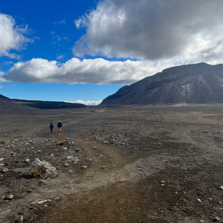
A quick egestion in the car park to toilets and I was off but not before a German couple requested, in their very serious no-nonsense way, I take their photo. I distanced myself from the pair as their chatter was obnoxiously loud tracking gradually up through native bush with kererū and riroriro song a plenty. Signs ahead warned of unexpected Lahars and to make haste just in case A lahar is a flood of water, volcanic mud, ash, and rocks. Lahars come from volcanic crater lakes or collapsed dams. Remobilisation of loose volcanic material during heavy rain also caused at least four lahars since October 2012. Damage from these incidents was still visible all around me as I made my way out of the bush into the mountain tussock.
The path steadily increased its incline and became more labour intensive. It was around 11 am that the flow of tourist hikers started coming down off the mountain in the opposite direction. A lot of Mōrena (morning) greetings and stepping off the path to give way to the increasing amount of downward traffic. This added a considerable amount of time to the hike but did give me the opportunity to rest up. My two-hour gym session and plasma donation the day before may not have been well-timed.
Signs warned, “You are hiking in an active volcanic landscape. Eruptions can occur at any time without warning”. I wondered to myself if this is what greeted those fateful visitors to Whakaari Island. I reached Ketetahi Hut (which is no longer present) as it was pummeled by rocks from the Te Maari eruption on the 6th of August 2012. Fortunately, no one was in the hut at the time. It was a little concerning to note that the hut will not be rebuilt here again due to its proximity to any future Te Maari eruptions. With the views of Lake Rotoaira fading behind me, I approached the north crater, as a large group of tourists gathered around the toilet facilities. The range of nationalities up here was extraordinary and hopefully a good sign for the tourist industry here in Aotearoa. Speaking with some of them they usually travel around New Zealand for a maximum of 6 months checking out the sights around our beautiful country. So that’s some serious ping coming into the country for that amount of time.


Rounding the central crater and past the blue lake, you really can’t take a bad photo - the scenery is just so surreal, Martian-like (I’m not going to go down the track of identifying it with the LOTR trilogy - that horse has been well and truly flogged!) but it really is quite incredible.
A British tourist stopped and identified the error in my decision to walk north rather than south “Look over there, mate! That’ll be a struggle with what you’re carrying!” I followed his arm to where he was pointing - a steep 350m gravel scree slope with tentative human ants descending its precipice with great care.


Between where I was and the climb was the large central crater - and expansive area -every location scout's wet dream! Planet of the Apes, Star Wars, Game of Thrones - you name it would love this as a backdrop! It really was epic and this took my mind off the task I had ahead of me.


I started the climb up the slope, and was pleased to note I was not the only foolish southbound hiker - there were three more ahead of me (with far lighter packs than mine) they soon vanished from view. As I gradually made my way up the sliding gravel slope, careful not to dislodge any large rocks that could possibly go hurtling down onto any unsuspected hiker I would stop and rest taking note of the majestic scenery which perchance included people wearing the most ill-equipped attire imaginable for such a feat.


The stunning Ngā Rotopounamu (Emerald Lakes) appeared to the left of me as I climbed and at last, I summited 1886 metres above sea level, this is the highest point formed mostly of scoria, the deep red and brown colours are caused by extreme heat oxidising the iron within the rocks. I rested and ate lunch (a ham wrap Jo had prepared for me to eat on the drive down to Turangi - so no, my pack was not getting any less heavy, as I was not eating my way through the food just yet.)


On the hike down yet another sign reminded everyone of Mother Nature's wrath and unpredictability


'On 19 February 1975, a Park Ranger and a guided school group got a little too close for comfort when a large, dramatic eruption of Ngāuruhoe occurred. They were halfway up Red Crater ridge when suddenly there was a loud noise followed by a huge cloud of dust and rocks (a pyroclastic flow) hurtling down the north slope towards the spot on the South Crater they had only left 20 minutes earlier.
Eruption after eruption sent hot waves of material down the mountain. Each took about one minute to descend - an average speed of about 80 km/hour. Then the volcano started getting even more active and, when the wind changed, rocks started falling near the group. Some exploded on landing - firing sharp fragments in all directions. They couldn't return the way they had come, so the ranger hurried everyone up toward Red Crater. They had made it to Central Crater, about 3.7 km from the crater of Ngāuruhoe, when a blast from a huge eruption blew them all off their feet. Fortunately, no one was hurt; but none of them would ever forget that eventful day.
It was a relief to be going down as opposed to up and more so when I could see my destination ahead - Mangitepopo Hut. Walking through this scorched earth reminded me of Rangitoto Island with its darkened scoria almost lifeless apart from the hardest of plants seeking refuge in its shadowy cracks where moisture can accumulate.
Boardwalks and marshes prequels the hut and as I approached it I soon became aware that I would not be sleeping on a comfortable mattress bunk bed as the hut was near capacity and tents were being erected around the hut. I was not deterred by this as I was looking forward to testing out my new Sea to Summit Ether Light XT Insulated Sleeping Mat.


It was a beautiful evening with an even more beautiful sunset beyond my maunga - Mt Taranaki in the distance and behind me the lazy moon appeared over the summit - a glorious, but chilly night.
TIME: 7:48. DISTANCE: 18.34km PACE: 25.31 ASCENT 1,162m CALORIES: 3,375
Wednesday 5 April 2023 / DAY ?: Well, that was a cold night. Clear skies meant no duvet lining of cloud to keep in the warmth over night. Still I was well impressed with my Sea to Summit sleeping mattress. My tent was wet with dew as I rolled it up, taking with it loads of little gravel stones - great! more weight for my pack! as if I needed it!
I was out of camp and on the trail by 7:30am and already the Tongariro Crossing was filling up with excited hikers keen to summit early to beat the rush. My GPS told me to go down towards Mangatepopo Road and walk along State Highway 47 to National Park Village but I was having none of that - so I back tracked until I found the track sidling around the mountain towards Whakapapa village.
Mt Taranaki was out in the distance as a reminder of home and I was walking towards it. I felt good. It was a beautiful day (unexpected as the weather prediction had not been that great). Another great day to cross the mighty Tongariro. It seems like yesterday but it was only 340,000 years ago to this day (or possibly not) that Tongariro exploded into life. If I'd been here 340,001 years earlier I'd be (very old now) and also incased in a giant Glacier! Pukekaikiore (loosely translated as "hill of the meal of rats" ('Puke' = hill, 'kai' = food/meal, and 'kiore' is the Polynesian rat). Some stories about the name infer that the 'rats' may have been a defeated māori tribe, beaten in battle, and then eaten as part of a feast). was formed by a lava flow which was obstructed by the glacier that filled this valley, diverted and grew into the distinctive mound it is today.
The most recent lava flow from Ngāuruhoe happened in 1954 so these very common warning signs telling us that "That mountains are still alive! and "Eruptions can occur at any time - without warning" should possibly taken with some consideration.
Have you ever noticed the colour of plants way up high here in the alpines? I certainly havent .There's a distinctive reddish, orange tinge to them all. It's all due to stress! Plants living in very wet, dry or cold places without any shelter are at risk of cellular damage. These plants often have more red pigment than other plants. Red pigments filter light and neutralise the damaging chemicals formed when plants are under stress. So there's something I didn't know!

The constant "u-tick" call of out native mātātā or fernbird flanked my walk through the many alpine bogs I walked through. Such an elusive bird calling from deep within the shrubs. I think I glimpsed one before it disappeared amongst the brush.
There were few hikers on this track, the couple I did meet were heading to Mangeatepopo Hut and then attempt the crossing the following day. Another couple I chanced upon after the woman had fallen and grazed her hand quite badly - I offered my first aid kit however the man with the brightly coloured LA Lakers cap seemed a little miffed at my presence and said he had it all under control.

The Chateau Tongariro appeared ahead of me which meant I could take a break, play some tennis, shoot some hoops, play on the kids playground or just set up my tent on the artificial lawn. I've never stayed here so I was a little sad that I would never have the opportunity to do so with it being closed down due to safety factors. The most recent seismic assessment found that underground shifts over time meant some of the hotel infrastructure no longer met current safety standards.
On closer inspection it certainly didn't look as pristine as the photo above. It resembled a ghost town with broken windows and unmowen lawns - what a shame.
Onwards I trudged along the Whakapapaiti Valley Track up and down the various valleys through small creek crossings before the descent towards Managhuia Campsite. I have to say I wasn't really feeling it. My feet hurt, possibly the new shoes - as my wider feet had not yet expanded into the narrower European shoe design of the La Sportiva brand. And I just felt tired - one of those thru hiker days when things just don't feel right. I'd thought perhaps I might have picked up covid along that way as I had a little sniffle.
I tried to keep my mind off the aches and pains - and what helped this were the constant roars of the red deer up high in the bush. Yes the "Roar" was on (The roar or rut is when deer stags (male deer) are most vocal, calling to attract the attention of hinds or any other male deer adversary (which they'll fight to the death if they have to to secure their mating rights). Red deer roar from late March through April. It's also when hunters get out and target these species with great enthusiasm, for some too much enthusiasm and a trigger finger mixed with "buck fever" can end the life of an innocent hunter. I picked up my pace as I wasn't keen on becoming another statistic.
On reaching Managhuia Campsite I was met with a bunch of white camper vans and their occupants setting up for dinner. A guy rushed out to say Hello and asked if I needed somewhere to stay. He was also a Te Araroa hiker and we briefly swapped stories on our adventures. National Park Village was around 7km down State Highway 47 and if I was lucky I might get someone to feel sorry for me and pick me up so I decided to walk the stretch of road from here to the village. It was a long walk with foot strikes sending pain up my legs on every stride. Dusk soon turned into darkness and for a little while there it rained. Headlights raced towards me and on one occasion a car veered towards me. "What a Dick!" I thought to myself. Wondering if he goes home to his wife or mother reviling on how he tried to scare a hiker by driving towards him! Weird!?

I limped into National Park Village and found my accomodation. Jo had phoned ahead and booked me into the YHA Apparently I had a dorm room with eight beds and only one other occupant, but when I got to my dorm I had the choice of the only the top bunk beds, the other four beds were occupied by young travellers from around the globe. I hasterly unpacked my charging devices and set these up to charge while I shot off to the Schnapps Bar for a meal. I felt I deserved this after my highway night walk and not becoming road kill. It was a bustling bar popular with locals and travellers alike. The Ribs went down a treat as did the Hazy Pale Ale. Fed and watered I took my leave and went back to the YHA, had a shower and climbed into my bunk bed. The guy below me was already snoring and did not stop all night long. The $70 price tag for a single room was too much for a one night stay i thought.
TIME: 11:09. DISTANCE: 30.94km PACE: 22.37 ASCENT 479m CALORIES: 3,242
Thursday 6 April 2023 / DAY ?: So in a dorm the last person to bed turns off the light. If that person comes to bed at 12am - thats when the light goes out. Needless to say it was another uncomfortable nights rest, with snoring and late arrivals. However the table turned when my alarm went off at 5:30am. I transported my pack and belongings out of the dorm and outside the door where I repacked my pack. I made good use of the kitchen facilities and cooked up a porridge, had a coffee and filled my water vessels.

It was drizzling when I left the YHA and I had another 31km day of walking ahead of me. The walk through town was uneventful as the community were slowly awakening to a grey day. The many Tongariro Crossing tour operators may not be so lucky today as it did not look like good weather to cross. I left the National Park Village and started on Fishers Track formed in 1896 to allow access to Retaruke and Kaitieke Valleys. The trail was likely used by early European settlers for horse coach traffic coming up from the Whanganui River at Wades Landing. The trail was re-imagined as a walking and cycling track from 2002 by a National Park Village community group and subsequent support from the John Key job summit in 2009. Today it is a superb day ride and a great section of the Mountains to Sea.
I runner stopped and chattered briefly before she took off in the direction I had come, probably to change into some warm dry clothes and have a hearty breakfast leaving me to venture further into the bush. I passed a Ute with its tail down displaying a couple of Quad Bike ramps. Obviously the owner had come onto Fisher track to do a spot of hunting yet I never heard an engine or a gun shot while I was on the track. I did however see a recently gutted deer on the side of the track so maybe he got in early.
Unlike earlier hikes this was one of ease walking along gravel roads which could accomodate cyclists of all abilities, yet, despite this, I did not see another person on the trail. What I did hear were the sounds of roaring deer again, it resounded around the valley. The guttural croaking of the fellow deer and the loud roaring of the red stags! It was great to hear. I followed suit and roared in a hind just over the hill to the side of the track but as I was not camouflaged I'm sure she saw my brightly coloured attire and legged it!
The smell of musk was in the air and before long the source of it made an appearance. Goats grazing along the side of the track sprinted off into the undergrowth as I approached, leaving behind their arid smell.

The trail takes you through Erua forest ecologically and geographically important, it is home to a significant fault line which contributes to the ranges and wetlands. The area is also home to unique and rare orchids, populations of Kiwi and regenerating bush. Old and abandoned farm houses are dotted along the route.
As I approached occupied farm houses my presence was announced by the ever alert Paradise Geese as they flew over head honking their warning cries. These were then added to by farm dogs as they ran up and down the fence parallel to the track barking and waving their tails. There must have been a dozen of these Australian Shepherd dogs wanting a piece of me!
On to Kaitieke Road for the final stretch, where I would set up camp and rest for the night, and to be honest it couldn't come quick enough. I was sore and was resting more than I should on such an easy track. It's said that walking the Te Araroa is best done as a thru hike as if you do it in stages - your body and fitness goes back to square one again when you start a new stage. This maybe the case for me.
But I was VERY happy when a hunter pulled up in his Ute and gave me a ride! He had two deceased deer on the roof of his vehicle which he'd just been paid $1500 for to take a father and son (who were driving the black Tesla in front of us) out to shoot. Not a bad way to make a buck - not so good for the deer I guess.


Winston (the hunter) dropped me off at the intersection of Oio and Upper Retaruke Roads where there is situated a 1st World War memorial, unveiled on 22 January 1923 and features a broken column to depict a life cut short. Adjacent to the memorial is a unique sculpture which was created entirely from old horseshoes to celebrate Horse of the Year. As I later found out my Trail Angel host was a very keen show jumper, dressage rider and ultra horse trekker - so the statue was very fitting with their house located just behind the monuments.
The accomodation provided a large lawn to camp on, or the choice of their shed, or bus, seperate shower facilities, Wifi and coffee and tea and breakfast the next morning. (all for $20)
The wifi was particularly handy as due to my decision to complete this section of the trail from April 4th to around April 16th I would miss our 2nd wedding anniversary. With some urgency I arranged flowers to be delivered to Jo (alas they could not deliver these on the anniversary but a day later).
It also gave me the ability to contact Blazing Paddles to check my kayak booking with them, as I had arranged and paid two nights accommodation on the river through the Dept of Conservation. And this is where things became unravelled. Although I had asked for a Kayak from Whakahoro (where I would be arriving the very next day after a 28km hike) Blazing Paddles had in fact booked me in from Taumaranui (I didn't want to spend 5 days on a kayak and I'd already walked past this section). Tour groups were already pulling out due to forecast so I made the call to end my section of the walk here and get back to Tāmaki Makaurau. Although disappointing I was not looking forward to walking the next day and it would be great to return one day with family and paddle the Whanganui river together. Perhaps the planets had aligned and I would be back in Auckland for our anniversary - which also saved me $ on flowers!
With all this now behind me and a decision made I had the best sleep ever on this night. Not even the barking sheep dogs or roaring stags kept me from my slumber.
TIME: No Data DISTANCE: 31km PACE: No Data ASCENT: No Data CALORIES: No Data
Friday 7 April 2023 / DAY ?: The day before, Roger had asked me what time I preferred breakfast, however as I was thinking I'd be on the trail early I declined the offer. With the latest change in plan I didn't wake up til the sun was well up. I took my time and packed everything down utilising the comfort of the shed to re pack my pack. There was to be a wedding in two days time at this very location so i tried to keep out of the owners way as much as i could.
I found a scrap piece of cardboard and wrote TURANGI on it in vivid maker. I find when hitchhiking this offers some insight that the person picking you up knows where you are going so they (a). know you won't be in their car with them for the duration of their trip or (b). know there's no point stopping if they're going in a different direction.
I said my goodbyes and told them of the kayak mix-up. Sharon offered to phone a friend of another Whanganui canoe company to book me in there - but by this stage my mind was made up. I congratulated the "newly weds to be" and hit the road. It was a pretty quite road so I had a few doubts as to when I would be picked up for a while - or in fact that I was hitching in the correct direction. But before long a guy in a large 4WD towing a trailer stoped and picked me up. And who would it be but the same company that had made the error with my kayak booking Blazing Paddles . Redemption time. We had a good chat and a laugh at the oversight and I told him we'd book in with them again.
Luke dropped me off at Taumaranui and then the first car that rounded the bend collected me and took me up the road 20 km or so! Brilliant I was on a roll my new companion was an old timer off to aim his rifles at a local shooting range. He was keen to get a good size trophy head in the roar as he'd been out of action for a while wth a broken leg. It was one of his bucket list items, he said.
On the side of the road again with my hitching stance, facing the traffic, relaxed (but not too relaxed - so they don't think you're a lay-about) Smile (but not too much so they think you're a looney) and the wave of acceptance when they drive right past you - no animosity right!

My last pickup were two young lads off to play a game of footie in Taupō. They were Taumarnui Distruct Prems vs Taupō United. By the looks of them - it would be a good game however the drivers passenger had his arm in a cast so he would not be partaking. It was a long drive to Turangi so i thanked them immensely and left them a packet of chewing gum and said I'd be at the game to see them win!
I arrived to pick up my car with a couple of pies from the Turangi Bakery and sat down with Nita and Bruce for a yarn and a cup of tea. Before long I was joining the holiday traffic and making my way north. As promised I stopped in at Owen Delaney Park in Taupō to watch the game. Taumaranui put up a good fight but unfortunately lost to the home team.
It's good to be Home.


Comments